Temperature
Rainfall
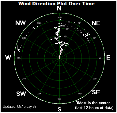
Wind |
11.2°C / 52.2°F/
0.0 mm since midnight
11.0 mph
from S |
Trend
30 minutes ago
2 hours ago
24 hour change |
+1.1°C/hr
10.2°C
9.7°C
+1.3°C |
Maximum Today
Minimum Today |
11.2°C at 10:19
8.5°C at 04:14 |
Date
average Max.
Humidity
87%
Apparent Temp (Feels like) |
12.3°C
min85%/max93%
7.2°C |
Barometer:
Steady
Change last 6 hours
last
12 hours
|
1014.2
mb
-1.0 mb
-2.2 mb |
Calculated Windchill
(more reliable in screenshot)
Lowest this month:
Heat Index/Dew point |
8.7°C
min: 5.9 at 08:08
-3.5°C
on 2/4/2026
11.1/9.1 |
Maximum Gust today
Last hour
Last 10 minutes av.
|
26.6 mph SSW at 08:57
23.8 mph N
at 09:43
14.2
mph
SSW
|
Maximum average speed
Today's average
direction
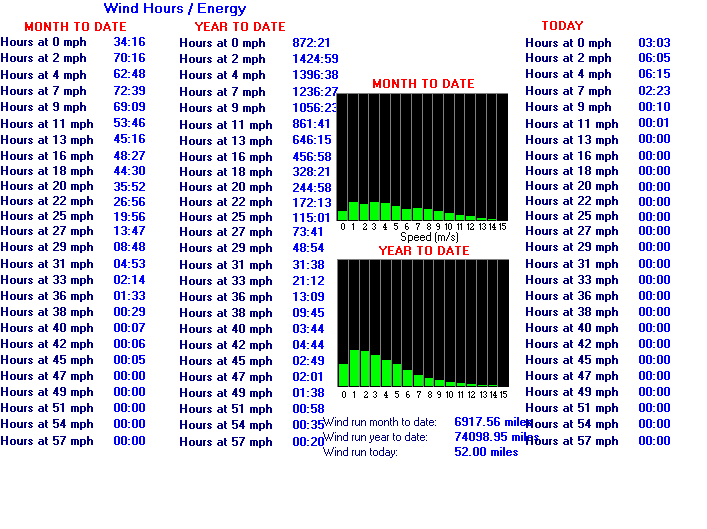
Windrun: Today/Month
Year so far
|
21.3mph
at: 10:13
South southwesterly
68.12 / 18008.98 miles
23672.62 miles
|
Rain so far today
Max rain rate today
Last tip of rain gauge |
0.0 mm
0.0 mm/hour
07:39 on 16/4/2026
|
Rain last hour
Yesterday
This Month
This Year |
0.0 mm
0.8 mm
17.6 mm
171.2 mm |
Has been raining for
This rainy period total
Theoretical snow level
|
0 mins
0.0
since 0/0/0
4739 ft asl
|
This month rain fell on
By this day
last month |
7 days
16.4 mm had fallen
|
Consecutive
dry days
Most together
this month:
Most together this year:
|
0 (from
now)
3
8 on 24/3
All time record - 29
|
Wettest day this month
Wettest day this year |
4.6 mm
(3/4)
12.2 mm (27/1/2026) |
Av.Temp last 24 hours
Av. Temp this month
Av. Temp this year |
10.5°C
8.0°C
5.2°C |
Max temp this month
Min temp this month
Max this year
Min this year |
20.4°C
-1.4°C
20.4°C
(8/4/2026)
-4.4°C
(4/1/2026)
|
Windchill low this year
Since records started
(March 2009) |
-12.1°C
on 5/1/2026
-14.6°C
13/2/2021 |
Max wind gust month
Av. direction this month |
70.2mph
on 5/4/2026
West southwesterly |
Freezing hours today
Lying snow now
Snowfall today
|
00:00hrs
0.0 in.
0.00 in.
|
Snowfall this month
Snowfall this season
Days snow falling season |
0 in.
0 in.
0 |
Rain 27th September 2024
Gauge was part blocked so correct total at least 60mm not 45mm
Recently significant - --- value 17.6 |
Archive data by
Month
|
Archive data by
Year
|


